| |
.
|
|
| Trimbe
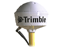
Global Positioning System Pro XRS |
| The
GPS Pathfinder® Pro XRS receiver is an easy-to-use
GIS data collection and data maintenance system
that provides real-time submeter accuracy. The
Pro XRS offers GPS, WAAS, satellite differential,
and beacon capabilities. The integration and flexibility
of these technologies means that you have less
equipment, cables, and batteries to carry.
Feature
and attribute data are input with the TerraSync™
software running on Trimble's GIS TSCe™
field device or a user-supplied Windows field
computer, Trimble's Asset Surveyor® software
running on the TSC1™ data collector, or
your existing data collection software. The
GPS Pathfinder Pro XRS system provides two-way
data flow between the field and GIS, facilitating
the data collection and data maintenance processes,
and ensuring that you always have current data
for decision-making.
Because the GPS Pathfinder Pro XRS integrates
real-time DGPS, it is easy to navigate directly
to an asset for verification and update. By
taking advantage of these real-time features,
you remove the need for postprocessing GPS data—further
closing the gap between field work and your
GIS.
KEY
FEATURES
incorporates a 12-channel, differential beacon,
and satellite differential receiver in one housing
WAAS differential ready
uses patented EVEREST™ multipath rejection
technology to remove multipath signals in reflective
environments
supports NMEA-0183 output and RTCM SC-104 input/output
|
|
|
[BACK
TO TOP]
[VIEW
PRODUCT SPECIFICATIONS,PDF]

|
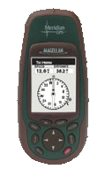
| Magellan
Meridian GPS |
| Meridian
GPS
The
rugged, cost-efficient Magellan® Meridian®
GPS is designed to make getting where you’re
going a fun, easy and safe trip, offering superior
tracking and accuracy to with 3 meters or better.
Easily navigate with a built-in 2 MB mapping
database of North America and unlimited expandability.
FEATURES
Accurate
Meridian GPS finds your location by tracking
up to 12 GPS satellites simultaneously. Assisted
by the U.S. Wide Area Augmentation System (WAAS),
the Meridian GPS is accurate to within 3 meters
or better.
Easy to use
An intuitive interface and large keyboard provides
direct access to key features, putting the power
of GPS at your fingertips.
Built-in mapping of North America and unlimited
expandability
Start navigating right away with a 2 MB, built-in
mapping database of North American, including
interstates, highways, major roads, waterways,
city locations, airports and more. Increase
your mapping detail by downloading street-level
maps on an optional Magellan SD memory card.
Full Featured Navigation
Seven customizable graphic navigation displays
show a map, compass, speedometer, and text readouts
of heading, bearing, speed, direction, ETA,
and more. Choose from 12 built-in coordinate
systems and 76 datums including Latitude/Longitude,
Universal Transverse Mercator, and Military
Grid Reference System.
Store routes and track-points
Store up to 20 routes, 500 waypoints and 2,000
track-points to easily find your way back again.
Save Track-to-Route
The unique, Save Track-to-Route feature allows
you to convert complicated track files into
easy to follow routes. Save hundreds of routes
by transferring them to a PC with Magellan MapSend®
software.
NorthFinderTM
NorthFinder technology shows your direction
even when standing still.
Sun/Moon positions
The Meridian GPS shows you when the sun will
rise and set, as well as the phase of the moon,
for any date and location in the world.
Fish and game calculator
Want to know when the fish are likely to be
biting in your little corner of the world? The
Magellan Meridian GPS can tell you.
Satellite status
Monitor the GPS satellites in view and get information
about their status.
Built
to perform on the most challenging and rigorous
adventure.
Large
backlit screen with easy to use interface
Easily view all the GPS information you need
to make your adventure fun and safe, even at
night.
Rugged
construction
Rubber armored, impact resistant plastic allows
you to confidently take your Meridian GPS on
that next great adventure.
Waterproof
Meridian GPS is sealed to IEC-529 IPX7 specifications
– and it floats!
Built-in help database
Meridian GPS is intuitive, easy to use, and
all the major functions are described in step-by-step
instructions.
Multiple language support
If you speak English, French, German, Swedish,
Finnish, Spanish, Italian, Portuguese or Dutch,
so does the Magellan Meridian GPS.
1 year warranty
We pride ourselves on building rugged and reliable
navigation products that you can depend on,
backed by a full one-year warranty.
|
|
|
[BACK
TO TOP]
|
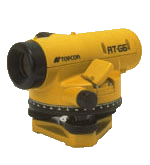
| Topcon
Survey Automatic Levels AT-G7 |
AT
Series
Topcon offers a wide range of automatic levels
for the land surveyor, civil engineer and contractor.
All AT-G series levels feature a magnetically-dampened
compensator hung by four special mylar ribbons
having superior resistance to cold, heat and shock.
The AT-G1 model features a 360° glass horizontal
circle using a 25x magnification microscope to
read the circle, while the AT-G2 thru AT-G7 have
a standard 360° horizontal circle. All models
are waterproof with a nitrogen gas sealed telescope
which prevents clouding and moisture on the lens.
|
|
|
|
|
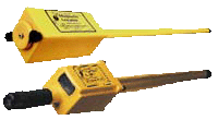
Schonstedt
Magnetic Locator Model GA-72 Cd
|
Easy-To-Use
The GA-52Cx and GA-72Cd Locators detect the magnetic
field of iron and steel objects and energized
power lines. Both provide audio detection signals
that peak in frequency when the locator's tip
is held directly over the target. The GA-72Cd
has the option of nulling or peaking
No.
1 Around the World in Performance and Reliability.
Quality
Is Our Hallmark
Schonstedt's underground magnetic locators have
been setting the standards for reliability and
dependability for over 30 years. They are designed
to withstand the rigors of daily on-site usage
and a wide range of environmental conditions.
In fact, the Model GA-52Cx is so rugged and
dependable it's backed by a 7-year warranty
and the
Model GA-72Cd is backed by a 5-year warranty.
Only
two Controls
Designed for one-hand operations, the On/Off-Sensitivity
and Volume controls are located on the underside
of the cover on both locators. This provides
easy access, protects the knobs and contributes
to their overall ruggedness and dependability.
The
GA-72Cd also has easy-to-read digital and bar
graph which displays of signal strength and
polarity. Once you have located a target using
the audio signal, the digital readout and polarity
indicators will help you to visually pinpoint
the target and, in some instances, even determine
its orientation.
Signal
Strength and Polarity Indications
The GA-72Cd's audio signal and the 3-digit LCD
readout will peak, and the (+) or (-) bar graph
will expand to full scale when its tip is directly
over a vertical iron pipe. One end of a horizontal
target will be (+) and the other will be (-).
This difference is very significant because
it helps you to distinguish between vertical
and horizontal pipes.
With the GA-72Cd you can select any one of four
sensitivity settings; the GA-52Cx offers five
sensitivity settings. The GA-72Cd's LCD bar
graph shows the selected gain and the battery
status. The GA-72Cd's headset jack can be connected
to your data logger using a standard stereo
audio plug.
Choice
of Two Audio Modes
The GA-72Cd is configured initially to provide
an audio signal that is always present (Audio
Output switch set to "B"). If you
do not want to hear a signal until the locator
is within the detection range of a target, you
can set the Audio Output Switch to "A".
FEATURES
Five Year Warranty
Digital readout and expanding bar graph displays
signal strength and polarity
4 Sensitivity settings: Low, Medium, High, and
Extra High
Piezoelectric speaker
Analog output for data logger entry
60-Hours operational life (intermittent usage)
on 2 lithium 9-volt batteries
First locator to use Environmentally Friendly
and Safe, lithium batteries. The unit is shipped
with two 9-volt lithium batteries installed,
and a spare set of batteries stored in the case.
Lithium batteries provide twice the life of
alkalines, and have a 10-year shelf life.
4-Segment BATT LCD monitors battery charge
Lightweight, easy-to-use-design reduces search
time
Modular construction; high performance components
Patented HeliFlux® sensors
No response to aluminum, brass, or copper
Y2K compliant
Both the GA-52Cx and the GA-72Cd are standard
with a custom case designed to withstand the
rigors of field use
SPECIFICATIONS
Output
Audio
Switch at "A" Signal increases or
decreases in volume with gradient-field intensity
Switch at "B" Signal increases or
decreases in frequency with gradient-field intensity
Visual Digital readout and expanding bar graph
indicate polarity (+ or-) and relative strength
of the magnetic field
Battery Life 60 Hours (intermittent usage)
Input Power Two lithium 9-volt batteries
Battery Check 4-segment LCD BATT indicator
Weight Approximately 2.5 lb. (1.14 kg)
Operating Temp -13o to 140oF (-25o to 60oC)
Overall Length 34.5 in. (87.6 cm)
Waterproof Length 21 in. (53.3 cm)
Nominal Sensor Spacing 14 in. (35.6 cm)
Construction Modular, all solid state
|
|
|
|
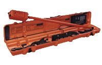
| Schonstedt
All Purpose MAC-51B Magnetic and Dual-Frequency
Pipe and Cable Locator |
| The
MAC-51Bx (the most cost-effective, all-purpose
locating system on the market) consists of a receiver
and a transmitter that simultaneously transmits
on two frequencies - 571 Hz (LF) and 82.5 KHz
(HF). The receiver has a three position switch
that lets you change modes, "on-the-fly",
between LO, HI, and MAG, for cable and line tracing
with break locating, pinpointing a ferrous metal
target, or identifying and pinpointing an energized
50/60 Hz power line.
In
the LO and HI modes, the receiver's audio signal
provides a sharp null when its tip is directly
over the target. In the MAG mode (no transmitter
required) the audio signal peaks when the receiver's
tip is over the target. You can trace the 571
Hz LF signal conductively applied to any continuous
metal conductor up to 4000 feet. The receiver's
on-the-fly mode-changing feature lets you locate
a complete break using the LO mode, and then
continue on to trace beyond the break in the
HI mode, or trace a metal pipe joined with non-conductive
gaskets.
The
MAC-51Bx by simultaneously transmiting 82.5
kHz (HF) and 571 Hz (LF) signals. This feature
lets you select and compare received audio signals
from both frequencies along with magnetic information
without having to return to the transmitter.
Transmitter
Inductive Mode (HF only)
Induction is achieved by placing the transmitter
over the target cable/pipe or by using the optional
Inductive Signal Clamp. It's the easiest and
quickest way to applying a trace signal that
is strong enough for tracing most lines. The
trace signal generates an alternating magnetic
field around the cable which induces a signal
into the receiver's cable sensor. A sharp null
in the audio signal between the two peaks occurs
when the receiver's tip is directly over the
cable.
Transmitter
Conductive Mode
If an exposed section of a target gas or water
pipe is accessible, conductive coupling is the
most reliable method for applying the trace
signal. This mode has to be used to apply both
HF and LF frequencies so that you can use all
three features on-the-fly. Providing a good
electrical contact between the clip and the
conductive portion of the target line by removing
rust or paint before attaching the clip is very
important.
Magnetic
Locating Mode
Only the MAC-51Bx receiver is required when
operating in the magnetic mode. Just set the
Mode switch to MAG, the Gain control to mid-range,
and you're ready to locate underground ferrous
pipes, water meters, water valves, and property
markers - or anything that has a magnetic field
including the 50/60Hz electro-magnetic field
generated by energized power lines.
FEATURES
Three Year Warranty
Two active frequencies for pipe, cable and line
tracing
Passive operation for locating iron and steel
targets and energized 50/60Hz power lines
Inductive and conductive signal coupling
Extra Heavy Duty Clips and Cable
Five discrete sensitivity settings
Receiver supplied with two environmentally friendly
9-volt lithium batteries
Piezoelectric speaker
45º Depth Measurement
Patented HeliFlux® Sensors
SPECIFICATIONS
-
Receiver -
Operating Voltage 9 V (2 alkaline or 2 lithium
batteries)
Battery Life 60hrs, alkaline (on & off usage
@ 70ºF)
120 hrs, lithium (on & off usage @ 70ºF)
Audio Output Approx. 40 Hz idling tone from
speaker
Freuency of pulsing tone (increases or decreases)
with signal intensity
Weight 2.64 lb. (1.20 kg.)
Operating Temp. -13oF to 140oF (-25oC to 60oC)
Overall Length 42.3 in. (107.4 cm.)
Waterproof Length 34.5 in. (87.6 cm.)
Nominal Sensor Spacing 20 in. (50.8 cm.)
- Transmitter -
Operating Voltage 12 V (8 alkaline C-Cell batteries)
Battery Life 60 hours (on & off usage @
70ºF)
RF Output 82.5 kHz modulated at 382 Hz, pulsed
at 4.4Hz
571 Hz Pulsed at 4.4 Hz
Audio Indicator 2.58 kHz pulsed at 4.4 Hz
Weight Approx. 5.5 lb. (2.5 kg.)
Operating Temp -13oF to 140ºF (-25ºC
to 60ºC)
Overall Size 43.5 in. x 7 in. x 5 in.
(110.5 cm x 17.8 cm. x 12.7 cm.)
|
|
|
|
.
|
|